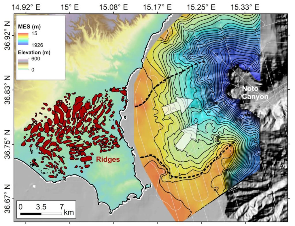

Mapped ridges in south-east Sicily and the buried canyon mapped from geophysical data upslope of Noto Canyon (Credit: Aaron Micallef)
In a nutshell
- Scientists have found definitive evidence of Earth’s largest known flood, which occurred 5 million years ago when Atlantic waters burst through Gibraltar and rapidly refilled the dried-out Mediterranean Sea with enough force to move 100 times more water than all of Earth’s current rivers combined.
- More than 300 massive, streamlined ridges discovered in Sicily point in the flood’s direction, along with a seafloor channel twenty times wider than Manhattan — providing the first complete chain of geological evidence for how this megaflood transformed the Mediterranean region.
- Computer models show the flood waters reached speeds of 70 mph and depths of 130 feet, lasting between 2-16 years — geological features from this ancient catastrophe have remained preserved for over 5 million years, suggesting similar evidence may exist elsewhere around the Mediterranean.
MOSS LANDING, Calif. — Five million years ago, nature orchestrated what scientists now confirm was Earth’s largest known flood, an event so massive it could have filled the Grand Canyon in just a few days. New research has uncovered compelling evidence of this ancient catastrophe, which transformed a largely dried-out Mediterranean basin into the vibrant sea we know today.
Scientists from the Monterey Bay Aquarium Research Institute and their international colleagues have discovered unmistakable signs of this prehistoric deluge in southeastern Sicily. Published in Communications Earth & Environment, their findings reveal how a massive torrent of Atlantic Ocean water burst through a natural dam near modern-day Gibraltar, carving lasting marks into the landscape as it rushed eastward.
Imagine the Mediterranean Sea completely drained, with vast salt flats stretching as far as the eye can see, dotted by scattered ultra-salty lakes, similar to Death Valley but covering an area larger than Texas. This was the Mediterranean’s state during what geologists call the Messinian Salinity Crisis, when the sea became cut off from the Atlantic Ocean and mostly evaporated under the hot sun.

Using modern technology and old-fashioned fieldwork, researchers found a series of telltale signs pointing to the flood’s immense power. In Sicily, more than 300 elongated ridges, some as long as several football fields, point like arrows in the direction the flood waters flowed. Rushing waters carved these streamlined islands in its path, scientists say.
“The morphology of these ridges is compatible with erosion by large-scale, turbulent water flow with a predominantly north easterly direction,” says study co-author Paul Carling, an Emeritus professor in the School of Geography and Environmental Science at the University of Southampton, in a statement.
These ridges tell only part of the story. Their tops are covered with layers of jumbled rock fragments, essentially nature’s version of flood debris. Much like how modern floods leave behind piles of debris, this ancient flood deposited chunks of rock and sediment as it surged across the landscape. But unlike typical flood deposits, these materials show signs of being laid down by water moving with extraordinary force.

Underwater surveys revealed another crucial piece of evidence: a massive channel carved into the seafloor, wide enough to accommodate Manhattan twenty times over. This ancient flood pathway connects the ridges on land to a huge underwater canyon, marking the flood’s route as it rushed toward the deeper eastern Mediterranean basin.
By comparing these geological features to computer simulations of the flood, researchers discovered something remarkable. As the torrent carved deeper channels, it actually gained power and slightly changed direction, precisely matching the patterns preserved in the rock record. Imagine water flowing through a hose — now picture that hose gradually widening into a canal, allowing the water to flow faster and with more force.
Just how powerful was this flood? At its peak, water rushed through this region at speeds approaching 70 miles per hour, with depths of up to 130 feet above the ridges. For comparison, this would be like taking all the water flowing through Earth’s rivers today and multiplying it by 100. The flood may have continued for anywhere from two to sixteen years, gradually filling the Mediterranean until it reached its present level.

Perhaps most remarkably, these flood features have survived for over five million years, preserved like an ancient crime scene waiting to be discovered. Their existence suggests similar evidence might be hidden elsewhere around the Mediterranean’s margins, offering opportunities for future discoveries.
“The Zanclean megaflood was an awe-inspiring natural phenomenon, with discharge rates and flow velocities dwarfing any other known floods in Earth’s history,” said lead author Dr. Aaron Micallef, a researcher at the Monterey Bay Aquarium Research Institute in California. “Our research provides the most compelling evidence yet of this extraordinary event.”
Understanding events like the Zanclean flood helps us appreciate how dramatically Earth’s geography can change over time. While no flood of this magnitude has occurred in human history, studying such extreme events provides valuable insights into our planet’s dynamic nature and its capacity for transformation.

Paper Summary
Methodology
The research combined traditional geological fieldwork with modern technology. Scientists examined and mapped hundreds of distinctive ridges in southeastern Sicily using both ground surveys and high-resolution elevation data from LiDAR scanning. They collected and analyzed rock samples to determine their age and composition. Marine seismic surveys created detailed images of underwater features. Computer modeling then simulated how flood waters would have behaved under different scenarios, allowing researchers to test their interpretations against the physical evidence.
Results
The study identified over 300 streamlined ridges aligned in the flood’s flow direction, covered with flood-transported rock debris. A 20-kilometer-wide erosional channel was discovered connecting these ridges to a deep submarine canyon. Computer models showed flood velocities reached 32 meters per second with water depths of 20-40 meters above the ridges. The flood’s direction shifted clockwise as it carved deeper channels, matching the observed ridge orientations.
Limitations
The researchers note that their computer models couldn’t fully reconstruct the maximum flood discharge rates suggested by other studies, partly due to uncertainties about the ancient geography of the region. The exact duration of the flood remains uncertain. Some flood deposits may have been lost to erosion over the past 5 million years.
Discussion and Implications
This research provides the strongest evidence yet for a catastrophic flood ending the Mediterranean’s isolation. The findings support the idea that the sea level had dropped dramatically before the flood. The preservation of flood features for millions of years suggests similar evidence might exist elsewhere around the Mediterranean, opening avenues for future research.
Funding and Disclosures
The research was funded by the National Geographic Society and the David and Lucile Packard Foundation. Additional support came from Spanish public agency grant PID2022-139943NB-I00. The authors declared no competing interests.
Publication Information
This study, titled “Land-to-sea indicators of the Zanclean megaflood,” was published in Communications Earth & Environment on December 28, 2024. The research team included scientists from multiple institutions across the United States and Europe, led by Aaron Micallef of the Monterey Bay Aquarium Research Institute.