
Credit: NASA Earth Observatory
NASA scientists have been tracking an alarming acceleration in landslides on the Palos Verdes Peninsula in California, where land is sliding toward the ocean at speeds of up to 4 inches per week.
Using advanced airborne radar, researchers mapped the movement of the unstable terrain and found that the affected area has expanded significantly, threatening homes and infrastructure.
Landslides on the Move: NASA’s High-Tech Analysis
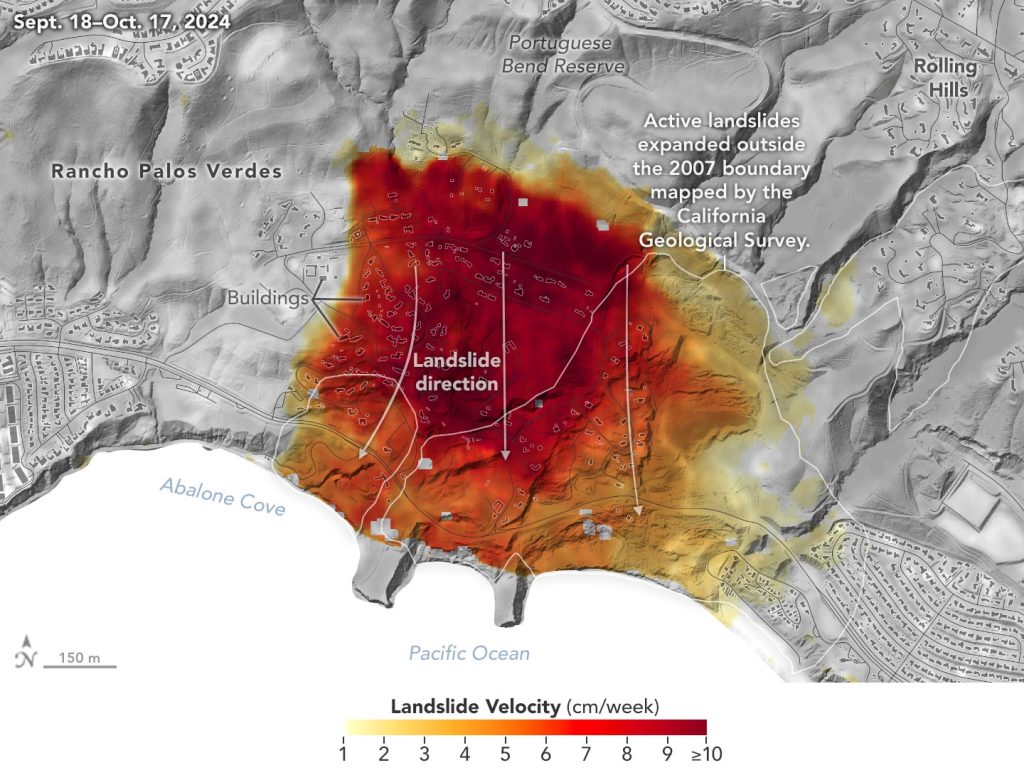
NASA’s Jet Propulsion Laboratory (JPL) in Southern California used airborne radar to track slow-moving landslides on the Palos Verdes Peninsula in Los Angeles County. Their analysis found that between September and October 2024, land in the residential area was sliding toward the ocean at a rate of up to 4 inches (10 centimeters) per week.
The Palos Verdes Peninsula, which extends into the Pacific Ocean just south of Los Angeles, sits atop an ancient landslide complex that has been shifting for at least 60 years. This movement has impacted hundreds of buildings in the area. In recent years, the rate of movement has increased, with the active landslide zone expanding after record-breaking rainfall in 2023 and heavy storms in early 2024.
Cutting-Edge Radar Captures Landslide Speeds
To create this visualization, the Advanced Rapid Imaging and Analysis (ARIA) team used data from four flights of NASA’s Uninhabited Aerial Vehicle Synthetic Aperture Radar (UAVSAR) that took place between Sept. 18 and Oct. 17. The UAVSAR instrument was mounted to a Gulfstream III jet flown out of NASA’s Armstrong Flight Research Center in Edwards, California, and the four flights were planned to estimate the speed and direction of the landslides in three dimensions.
In the image above, colors indicate how fast parts of the landslide complex were moving in late September and October, with the darkest reds indicating the highest speeds. The arrows represent the direction of horizontal motion. The white solid lines are the boundaries of the active landslide area as defined in 2007 by the California Geological Survey.
A Growing Risk to Lives and Infrastructure
“In effect, we’re seeing that the footprint of land experiencing significant impacts has expanded, and the speed is more than enough to put human life and infrastructure at risk,” said Alexander Handwerger, the JPL landslide scientist who performed the analysis.
The insights from the UAVSAR flights were part of a package of analyses by the ARIA team that also used data from ESA’s (the European Space Agency’s) Copernicus Sentinel-1A/B satellites. The analyses were provided to California officials to support the state’s response to the landslides and made available to the public at NASA’s Disaster Mapping Portal.
Handwerger is also the principal investigator for NASA’s upcoming Landslide Climate Change Experiment, which will use airborne radar to study how extreme wet or dry precipitation patterns influence landslides. The investigation will include flights over coastal slopes spanning the California coastline.
More About ARIA, UAVSAR
The Advanced Rapid Imaging and Analysis (ARIA) project is a collaboration between NASA’s Jet Propulsion Laboratory (JPL) and Caltech, designed to harness radar and optical remote sensing, GPS, and seismic data for scientific research and disaster response. ARIA focuses on monitoring and analyzing natural hazards, including earthquakes, volcanoes, landslides, wildfires, and subsurface fluid movement, providing valuable insights for both scientific understanding and emergency management.
The Uninhabited Aerial Vehicle Synthetic Aperture Radar (UAVSAR) is a powerful airborne radar system that has conducted thousands of missions worldwide since 2007. Mounted on a Gulfstream III aircraft, UAVSAR is used to study a wide range of Earth processes, including glacial movement, ecosystem changes, and natural disasters such as earthquakes, volcanic activity, and landslides. Its high-resolution imaging capabilities make it a critical tool for detecting subtle ground movements and assessing environmental changes over time.