

A partnership between scientists and facility managers to enhance climate resilience at NASA.
About CASI
CASI’s mission is to provide the latest scientific research on climate change to help NASA facilities managers adapt to increasing climate risks in timely and effective ways. The CASI science products are created and shared through working groups that include topics such as water management, ecosystems, energy, air quality, wildfires, sea-level rise, and extreme weather events.
CASI Ecosystem Workflow
The CASI Ecosystems Workgroup is providing information for NASA facilities managers and for their surrounding natural landscapes on the presence of endangered species, invasive species, biodiversity, and carbon pools. The webpage applications assembled below are the tools to use for CASI ecosystem change assessments.
Step One
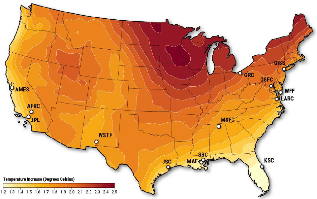
Find Location in Climate Change Ecosystem Finder
The Climate Change Ecosystem Finder allows users to find temperature predictions for any ecosystem in the U.S., up to the year 2100.
This application has instructions that will allow a user to select a study site of interest on the U. S. map, such as a NASA Center or a protected parkland area, and running a climate change assessment for the region.
Explore the Climate Change Ecosystem Finder about Find Location in Climate Change Ecosystem Finder
Once you have selected your location of interest, you can input the coordinates generated from the Climate Change Ecosystem Finder into the three applications listed below. Together, these applications will provide a look at the expected changes in temperature, endangered species, invasive species, biodiversity, and carbon pools in and around the selected location.
Step Two
Find Endangered Species using the IUCN’s Red List
Established in 1964, the International Union for Conservation of Nature’s Red List of Threatened Species has evolved to become the world’s most comprehensive information source on the global extinction risk status of animal, fungus and plant species.
The IUCN Red List is used by government agencies, wildlife departments, conservation-related non-governmental organizations (NGOs), natural resource planners, educational organizations, students, and the business community.
Explore the IUNC Red List Map about Find Endangered Species using the IUCN’s Red List
To use the coordinates you identified in the Climate Change Ecosystem Finder, navigate to the “Type: Species” feature option.
Step Three
Find Invasive Species using INHABIT
INHABIT is a U. S. Geological Survey web application and decision support tool with mapped and tabular summaries of habitat suitability models for over two hundred fifty invasive plant species of management concern.
INHABIT is the product of a scientist-practitioner partnership developed at the U. S. Geological Survey designed to facilitate enhanced invasive species management actions, including species watch-lists and targeted searches.
Explore the INHABIT Map about Find Invasive Species using INHABIT
To use the coordinates you identified in the Climate Change Ecosystem Finder, navigate to the “Select a species” feature option.
Step Four
Find Biodiversity and Carbon Pools using Restor
Key features of Restor include project mapping, access to biodiversity and carbon cycle data, monitoring tools, funding opportunities, and collaboration tools.
Restor enables users to monitor the ecosystem health of any location of interest by providing access to project databases on biodiversity indices, biomass pools, soil water, and more.
Explore the Restor Map about Find Biodiversity and Carbon Pools using Restor
To use the coordinates you identified in the Climate Change Ecosystem Finder, navigate to the “Welcome to Restor: Draw a shape” feature option.
Keep Exploring


