Much of the eastern U.S. endured a renewed round of harsh, soggy weather on Saturday, with snowstorms predicted in the Northeast and heavy winds brought the threat of tornadoes to the Mississippi Valley.
Kentucky, Tennessee, West Virginia and Arkansas were under flood warnings, and residents were warned by the National Weather Service to stay off roads. Parts of western Kentucky faced up to 8 inches of rain.
The Kentucky River Medical Center in the city of Jackson said closed its emergency department and was transferring all patients to two other hospitals in the region. The hospital said it would re-evaluate conditions Sunday morning to determine when it can safely reopen. The north fork of the Kentucky River was forecast to crest nearly 14 feet above flood stage that afternoon, the weather service said.
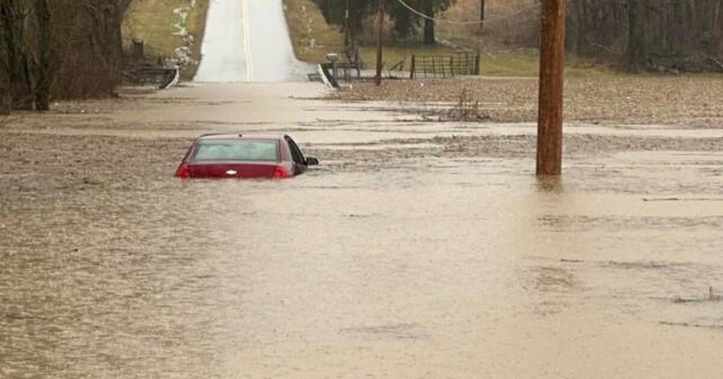
Photos posted by authorities and users on social media showed cars and buildings underwater in Warren County, Kentucky, and in Buchanan County, Virginia, where the sheriff’s office said multiple roads were blocked by mudslides.

Warren County Sheriff’s Office
The Simpson County Office of Emergency Management in Kentucky said authorities performed several rescues from stalled-out vehicles in floodwaters.
“Stay home if you can,” the office said on Facebook.
Gov. Andy Beshear preemptively declared a state of emergency in Kentucky, where flash flooding was expected into Sunday. Flash flooding hit some roads Saturday in Bowling Green, Kentucky.
“We want to specifically put assets in places that flood and have flooded in the past,” Beshear said on social media.
The weather service said flash flooding was possible in the Mississippi, Tennessee and Ohio valleys. In Tennessee, flash flood warnings were issued for much of the middle of the state through the evening.
The National Weather Service called the expected rain a “major, potentially historic, flash flood event.”
Meanwhile heavy snow was expected to blanket much of New England and then transition to sleet, making travel nearly impossible. The heaviest accumulations — possibly a foot or more — were expected in upstate New York and portions of northern New England.
In northern New York, heavy mixed precipitation was expected throughout the weekend. CBS News New York meteorologist Craig Allen said New York City’s northwest suburbs could see 3 to 7 inches of snow followed by freezing rain.
“Power outages and tree damage are likely due to the ice and strong winds. Travel could be very difficult to nearly impossible, the NWS said.
Snow and arctic temperatures swept much of the Midwest and Upper Plains, covering roads in eastern Nebraska, northern Iowa and much of Wisconsin. Winter weather advisories were issued for parts of those states and Michigan, with up to 4 inches of snow predicted throughout Iowa, southern Wisconsin and most of Michigan by Sunday evening.
Frigid polar vortex arrives Saturday
Meteorologists warn that the U.S. was about to get its 10th and coldest polar vortex stretching event this season, with the northern Rockies and northern Plains first in line. Weather forces in the Arctic are combining to push the chilly air that usually stays near the North Pole into the U.S. and Europe.
In Denver, where temperatures were expected to dip as low as 14 degrees over the weekend, the city opened shelters for those living on the streets.
Forecasters reported an inch of snow falling every hour just north of Denver. In Boulder County, an unoccupied vehicle that was stuck in the snow after attempting to cross railroad tracks was struck Saturday afternoon and mangled by a train. There were no injuries, but authorities warned drivers about slick roads.
In the Rocky Mountains, skiers eager for the long Presidents’ Day weekend are already facing a closure on a section of Interstate 70 due to snow as officials warn of hazardous conditions on the mountain roads over the weekend.
The weather service also warned of extreme cold in the Upper Plains over the coming days, with wind chills ranging from minus 30 degrees to as low as minus 60 in parts of western Montana, North Dakota, northern South Dakota and western Minnesota. People in those areas were urged to stay indoors and make provisions to shelter livestock and other animals.
California struggles with mudslides
Dry weather returned to southern California after the strongest storm of the year but the risk of rock and mudslides on wildfire-scarred hillsides continued Friday since dangerous slides can strike even after rain stops, particularly in scorched areas where vegetation that helps keep soil anchored has burned away.

Damian Dovarganes / AP
Water, debris and boulders rushed down the mountain in the city of Sierra Madre on Thursday night, trapping at least one car in the mud and damaging several home garages with mud and debris. Bulldozers on Friday were cleaning up the mud-covered streets in the city of 10,000 people.
A storm in the Sierra Nevada mountains dumped 6 feet of snow over 36 hours. Two ski patrol staff from Mammoth Mountain were caught in an avalanche during avalanche mitigation work Friday morning, the resort said in a Facebook post. One was extracted and was responsive, while the other was taken to a hospital with serious injuries.