Fierce winds and months of drought set the conditions for the catastrophic wildfires in Los Angeles this month. But the growth of housing in and around the city’s fire-prone hills over the past few decades also played a major role.
Most of the homes that have been damaged or destroyed so far were nestled in or near hillsides covered with highly flammable vegetation. Even dense urban neighborhoods like Altadena were vulnerable to embers blown from the burning hills nearby.
Across the country, including in California, millions of Americans have been moving to places at risk of burning, particularly developments on the outskirts of cities that bump up against forests, grasslands and shrub lands. The rapid growth in these areas, known as the “wildland-urban interface,” has increased the odds of devastating blazes, especially as climate change fuels larger and more intense wildfires across the West.
Between 1990 and 2020, the number of homes in fire-prone parts of California grew by 40 percent, according to research led by Volker Radeloff, a professor of forest ecology at the University of Wisconsin-Madison. By contrast, the number of homes in less-flammable areas — such as downtowns — only grew by 23 percent.
Across the West, there are now more than 16 million homes in the wildland-urban interface, or WUI (pronounced “woo-ee”).
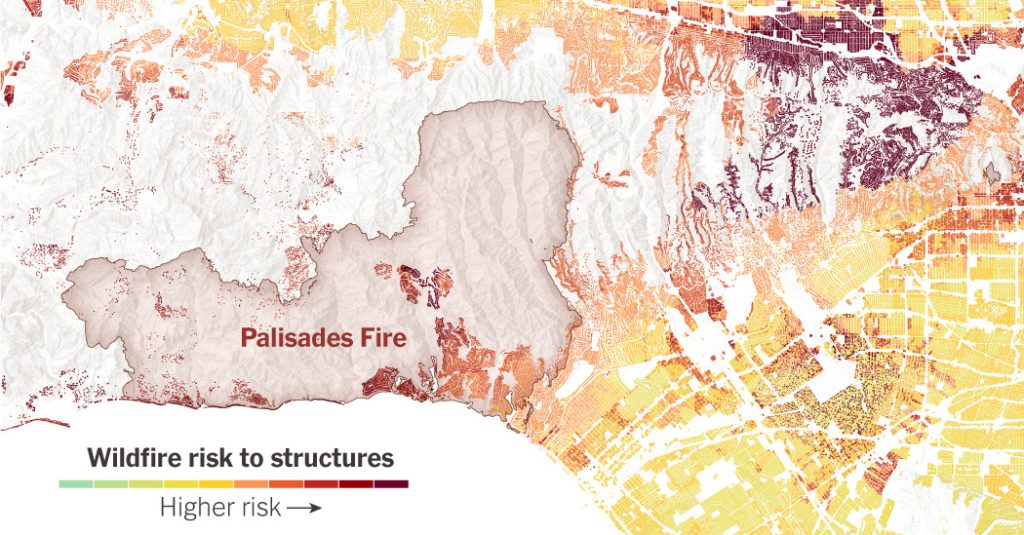
When wildfires erupt, they tend to do the most damage in these zones where developments encroach on wilderness. Examples include the Palisades Fire last week, where a brush fire quickly spread to 1,000 houses and buildings in an upscale neighborhood. Or the Camp Fire in 2018 that incinerated Paradise, Calif, a town surrounded by forests.
If someone had walked through these communities a week before the fires, they would never think that they were fire-prone, said Dr. Radeloff. “Their distance from natural vegetation seems way too far, but it’s not. Fire scientists know that it is not.”
Source: CoreLogic, Cal Fire
Note: Fire perimeters as of Jan. 14 at 12 p.m. PDT.
Americans often move to the WUI to be closer to nature or because homes are cheaper. In California, many cities have restricted development in downtown areas, pushing people to the fringes. Mobile homes and low-income housing are prevalent in fire-prone areas.
Since 2020, when the pandemic accelerated moves away from city centers, Los Angeles County as a whole lost population but both the Palisades and Altadena saw moderate gains.
Data from Corelogic, a property and risk analytics firm, show that around 1 in 8 properties in California now face “very high” fire risk. In Los Angeles County, that figure is closer to 1 in 10, with newer buildings slightly more likely to be in wildfire-prone areas than those built before 2000.
Source: CoreLogic, Cal Fire
Note: Fire perimeters as of Jan. 14 at 12 p.m. PDT.
“Especially in the Western U.S., we’ve been growing like gangbusters out into the WUI for the last few decades,” said Andrew Rumbach, a senior fellow at the Urban Institute, a nonprofit organization. “The amount of exposure to wildfire events is getting higher and higher.”
The growth of housing in flammable areas is a big reason that wildfires are becoming more destructive. Not only are there more homes in the path of fires, but with more people living near forests and grasslands, there’s a greater chance fires will start in the first place. Humans themselves cause the vast majority of wildfire ignitions: a cigarette thrown out the window, or a hot lawn mower engine setting fire to dry grass.
More homes in fire-prone territory also increases the demand to put out fires in often difficult terrain, which can stretch firefighting resources thin.
Urban sprawl wasn’t the only reason the Los Angeles fires have been so devastating. Many of the homes in Pacific Palisades were 40 to 100 years old, and had avoided damage for many years in a region that burns frequently, said Crystal Kolden, director of the Fire Resilience Center at the University of California, Merced.
But this time, there was more fuel and stronger winds. Much of the surrounding area used to be ranch land, and cattle grazing kept the buildup of flammable shrubs and grasses in check. Some of that land has since been converted into a park and a conservation area, allowing more vegetation to grow. A combination of a brutal drought — Los Angeles has gone eight months without rain — and hurricane-strength Santa Ana winds supercharged this week’s devastating fires.
“Palisades is an absolutely beautiful place, so people are going to move back there,” Dr. Kolden said. “My hope is that they stop and ask themselves, how can we build back better so that this doesn’t happen again.”
Learning to ‘coexist’ with fire
It’s hard to imagine that millions of Americans will suddenly stop living near wildlands. That makes it critical to do more to protect homes and communities against fire.
“We need to start looking at these wildfires as inevitable and learn to coexist with them,” said Max Moritz, a wildfire expert at the University of California, Santa Barbara.
A home in Paradise, Calif., burning in the Camp Fire in 2018.
Josh Edelson/AFP via Getty Images
Smoke from the Palisades fire in the Santa Monica Mountains National Recreation Area near Los Angeles last week.
Loren Elliott for The New York Times
Protections include building houses that are better fortified against burning embers carried by the wind, which can blow into homes through vents in the eaves or sides. It would also include creating more “defensible space” around homes and neighborhoods, cleared of brush and vegetation, to keep blazes at a distance, said Anne Cope, chief engineer at the Insurance Institute for Business & Home Safety.
Since 2008, California has adopted some of the strictest rules in the country for new homes in high-risk fire areas, requiring developers to use fire-resistant materials and to provide access to water for firefighters. Another rule, adopted in 2023 but not yet in force, would require homeowners in fire-prone areas to remove anything flammable — such as bushes or wood fences — from within five feet of their home. Some communities use orchards, farmland or other buffers against encroaching wildfires, said Dr. Moritz.
Those actions can make a difference. After the Camp Fire, one analysis found that about 51 percent of the 350 single-family homes in Paradise built to the new codes escaped damage, compared with just 18 percent of the 12,100 homes built before the standards.
But new rules take time to have an effect, and the building codes don’t apply to older homes, which can be expensive to retrofit. Outside of California, many Western states don’t have statewide codes, leaving it to local governments to enforce standards.
In many cases, homeowners, state agencies and the federal government will have to do more to prevent vegetation buildup around high-risk areas, experts say. That’s not always easy: In places like the Santa Monica Mountains near the Pacific Palisades, using prescribed fire to curb vegetation isn’t effective, according to the National Park Service. Elsewhere, worker shortages and environmental regulations have hampered forest-thinning efforts.
States might also impose tighter restrictions on development in some of the highest-risk areas. While some governments have paid people to move off land that floods repeatedly, the idea is rarely considered for wildfires.
At the same time, California is facing an acute housing shortage, and experts say that any restrictions on development would need to be paired with an effort to allow more homes to be built in lower-risk areas, like city centers.
“Encouraging infill development in cities in order to take pressure off the WUI areas is a huge part of the equation,” said C.J. Gabbe, an environmental scientist at Santa Clara University.
A rush to rebuild
When neighborhoods burn down, many residents want to rebuild quickly, with few restrictions. After the Marshall Fire near Boulder, Colo., in 2022, some communities agreed to stricter building codes, but others pushed back against requirements to use fire-resistant materials or to add sprinklers inside rebuilt homes, because it would have increased costs, said Mr. Rumbach of the Urban Institute.
“People want to be safe, but in a recovery, cost and the ability to rebuild quickly are also important,” said Mr. Rumbach. “You often see a tension between the two.”
A neighborhood of Louisville, Colo., after the Marshall Fire on Jan. 2, 2022.
Erin Schaff/The New York Times
New homes under construction in a development wiped out by the Marshall Fire in Superior, Colo., in 2023.
David Zalubowski/Associated Press
Rising home insurance costs could force changes. As insurers pull back from fire-prone parts of California and premiums spike, many communities could look at ways to significantly lower their risk, said Dr. Kolden of the University of California, Merced.
Some have started: In 1990, after the Painted Cave Fire hit Santa Barbara, Calif., burning 427 homes and killing one person, the nearby community of Montecito took action. The local fire protection district now works with residents to harden homes against fire, thinning out native shrubs on private property and requiring changes in building codes, such as wider driveways for fire engines.
Those efforts were tested in the Thomas Fire in 2017, when high winds brought flames to Montecito’s doorstep. This time, only seven houses were destroyed.
“There are lots of disasters we have limited control over,” said Dr. Kolden. “But fire is one we do have control over. We can control the fuel. We can control what our structures look like.”
“It’s hard when it’s not fire season to keep up that momentum,” she added. “But right now, in the wake of a disaster, every other community that has any kind of fire danger should be looking at what they can change and saying, ‘Today’s the day we start.’”
Methodology
Fire risk scores from CoreLogic are based on average annual loss estimates and are displayed at the parcel level. Risk is assessed for the main property on each parcel if there were multiple structures, and the higher risk score is used if structure sizes are similar.
