
 BBC Burmese Service
A huge earthquake has hit central Myanmar.
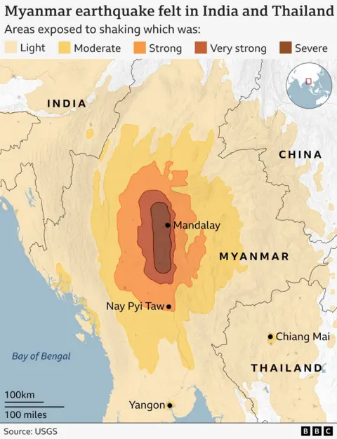
The magnitude-7.7 tremor was felt elsewhere, including in Thailand and south-west China.
More than 1,600 people have died and more than 3,000 have been injured, although it is difficult to obtain accurate information.
Here is what we know so far.
Where did the earthquake strike?
The earthquake’s epicentre was located 16km (10 miles) north-west of Myanmar’s city Sagaing, the US Geological Survey (USGS) said.
This is also near Myanmar’s second-largest city, Mandalay, with a population of about 1.5 million people – and about 100km (60 miles) north of the capital Nay Pyi Taw.
The first earthquake struck around 12:50 local time (06:20 GMT) on Friday, according to the USGS. A second earthquake struck 12 minutes later, with a magnitude of 6.4. Its epicentre was 18km (11 miles) south of Sagaing.
Which areas were affected?
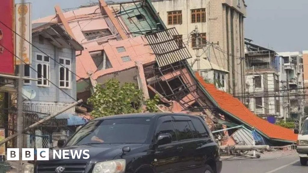
In Myanmar, there are reports of roads buckling in the capital in addition to damage to buildings across the country.
The ruling junta said 1,591 houses had been damaged in Mandalay region.
Strong tremors were also felt elsewhere, including in Thailand and south-west China.
In the Thai capital Bangkok, about 50 construction workers are unaccounted for and six dead after an unfinished high-rise building collapsed.
“We always have hope. We work tirelessly and are still working around the clock to make sure that everybody is safe,” Thai Deputy Prime Minister Anutin Charnweerakul told reporters.
Rescue officials at the site said they detected at least 15 people alive but very deep under the rubble.
A video also showed a rooftop pool in Bangkok spilling over the sides of a swaying building.
How deadly was it?
The official death toll now stands at 1,644. Many of the fatalities were in Mandalay.
More than 3,400 people were injured and 139 are missing.
Rescue operations are ongoing, with one rescue team in Mandalay saying they were “digging people out with our bare hands”.
How hard is it to find out what’s happening in Myanmar?
Getting information out of Myanmar, formerly known as Burma, is difficult.
Myanmar has been ruled by a military junta since a coup in 2021, complicating access to information.
The state controls almost all local radio, television, print and online media. Internet use is also restricted.
Mobile lines in the affected areas have been patchy, but tens of thousands of people also live without electricity, making it difficult for the BBC to reach residents.
Foreign journalists are rarely allowed into the country officially.
What causes earthquakes?
The Earth’s crust is made up of separate bits, called plates, that nestle alongside each other.
These plates often try to move but are prevented by the friction of rubbing up against an adjoining one.
But sometimes the pressure builds until one plate suddenly jerks across, causing the surface to move.
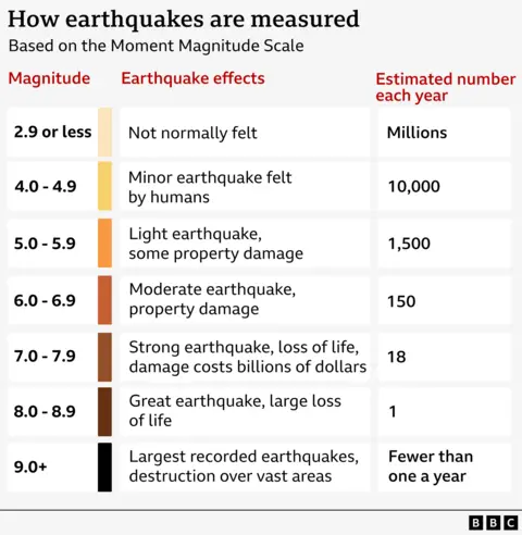
They are measured on a scale called the Moment Magnitude Scale (Mw). This has replaced the Richter scale, now considered outdated and less accurate.
The number attributed to an earthquake represents a combination of the distance the fault line has moved and the force that moved it.
A tremor of 2.5 or less usually cannot be felt, but can be detected by instruments. Quakes of up to five are felt and cause minor damage. The Myanmar earthquake at 7.7 is classified as major and usually causes serious damage, as it has in this instance.
Anything above 8.0 causes catastrophic damage and can totally destroy communities at its centre.
Is it safe to travel to Myanmar, Thailand or Laos?
The UK’s Foreign, Commonwealth & Development Office (FCDO) has warned about the possibility of several strong aftershocks in places affected by the earthquake.
It has advised people in the area, or tourists planning to travel to Myanmar, Thailand or Laos, to monitor local media and follow the advice of local authorities and tour operators.
The FCDO has also previously issued advice against travel to parts of Myanmar and all-but essential travel to parts of Thailand and Laos.
Myanmar’s security situation “may deteriorate at short notice and the military regime can introduce travel restrictions at any time” amid an “increasingly volatile” conflict, it said.
The FCDO’s warning for parts of Thailand is “due to regular attacks in the provinces by the border with Malaysia” and its advice for Laos relates to “intermittent attacks on infrastructure and armed clashes with anti-government groups” in Xaisomboun province.
How does this compare with other large earthquakes?
This earthquake and its aftershocks were relatively shallow – about 10km in depth.
That means the impact on the surface is likely to have been more devastating than a deeper earthquake, with buildings shaken much harder and more likely to collapse.
On 26 December 2004, one of the largest earthquakes ever recorded struck off the coast of Indonesia, triggering a tsunami that swept away entire communities around the Indian Ocean. That 9.1 magnitude quake killed about 228,000 people.
The largest ever earthquake registered 9.5 and was recorded in Chile in 1960.